Ratio.City
Ratio.City is a web-based geospatial software providing housing and development data to help municipalities, developers, and planners.
What is Ratio.City?
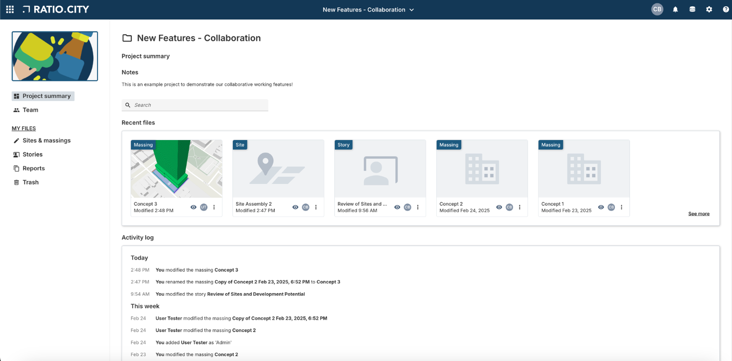
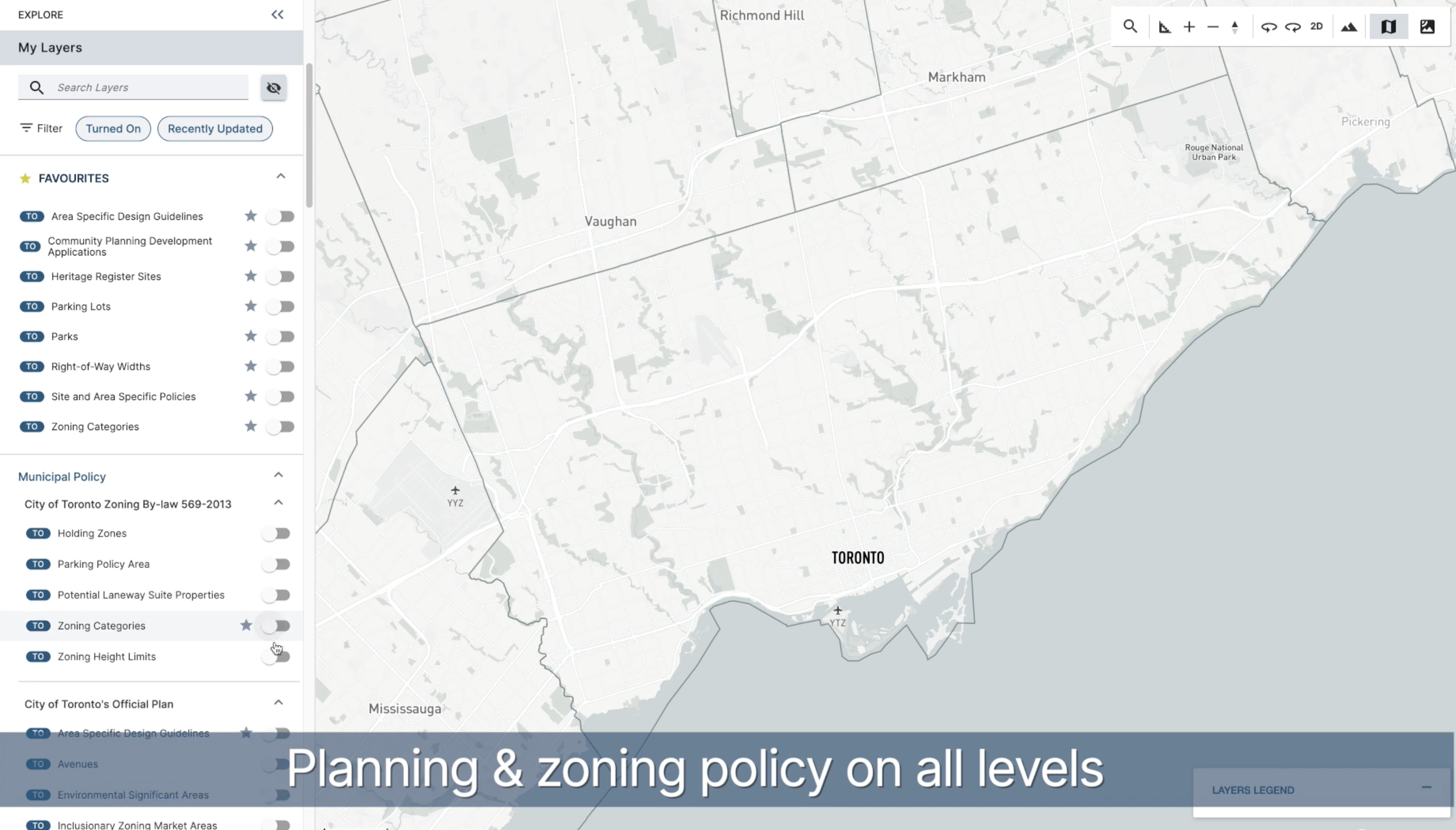
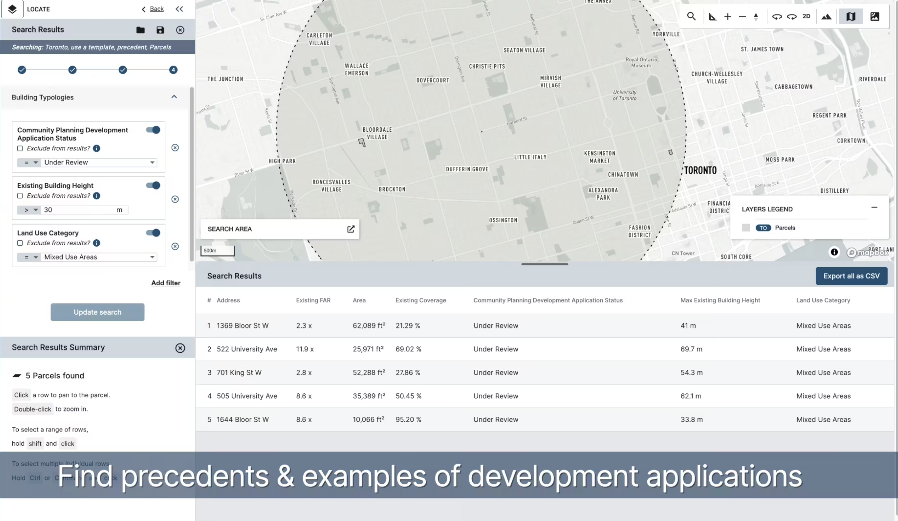
Ratio.City is a web-based geospatial platform that helps Canadian municipalities, developers, architects, and planners make faster, data-driven housing and planning decisions. The platform combines curated land use, zoning, and infrastructure data with intuitive mapping, 3D modeling, and reporting tools to streamline feasibility studies and pre-application workflows. Users can search for sites, compare parcels, test development scenarios, and visualize policy constraints all in one place. Ratio.City also includes dashboards to track housing supply and demand, ensuring alignment with municipal goals. Currently available in major markets including Toronto and Vancouver, Ratio.City transforms complex planning data into clear, actionable insights that save time and reduce risk.
Screenshots
Video
Categories
Features
FAQ
The official website of Ratio.City is https://www.ratio.city/
Ratio.City is a web-based geospatial platform that helps Canadian municipalities, developers, architects, and planners make faster, data-driven housing and planning decisions. The platform combines curated land use, zoning, and infrastructure data with intuitive mapping, 3D modeling, and reporting tools to streamline feasibility studies and pre-application workflows. Users can search for sites, compare parcels, test development scenarios, and visualize policy constraints all in one place. Ratio.City also includes dashboards to track housing supply and demand, ensuring alignment with municipal goals. Currently available in major markets including Toronto and Vancouver, Ratio.City transforms complex planning data into clear, actionable insights that save time and reduce risk.
Ratio.City belongs to the GIS category.
Ratio.City offers features such as 3D Imaging, Color Codes/Icons, Data Import/Export, Data Mapping, Geographic Maps.
No, Ratio.City does not offer a free trial.
Pricing
Starting at:
$100/per month
Free Trial Available
Reviews(0)
Write a reviewRatio.City alternatives
Google Maps
Google Maps is a mapping software that provides users with an interactive map to view locations and directions. The software utilizes satellite imagery, street maps, and 360 panoramic views of streets to display geographic information for over 220 co...load more
EZO
EZO helps small businesses manage inventory and assets across multiple locations, with strong support for check-in/check-out workflows and real-time tracking. Reviewers highlight its ease of use and asset visibility, though some cite UI friction and ...load more
UpKeep
UpKeep is a maintenance management tool mainly used by small businesses in industries such as real estate, food and beverage, and healthcare that need to manage maintenance tasks across multiple sites. Its notable for its mobile-first design and prev...load more
MaintainX
MaintainX is a maintenance management tool used mainly by small businesses in facilities services, automotive, and food and beverage. It stands out for its mobile access and preventive maintenance scheduling, its intuitive interface, and real-time wo...load more
ArcGIS
Integrated collection of GIS software products; ArcGIS offers unique capabilities and flexible licensing for applying location-based analytics to your business practices. Gain greater insights using contextual tools to visualize and analyze your data...load more
Surfer
Surfer is the most complete platform for AI Search Optimization and visibility. It helps your brand show up where real decisions happenon Google, inside AI-generated answers, and across the web. With Surfer, you create content LLMs want to cite and t...load more
Asset Essentials
Asset Essentials is a cloud-based maintenance solution that generates operational insights from asset and work order management activities. The solution collects and consolidates facility asset data and repair histories, yielding increased asset visi...load more
Fulcrum
Fulcrum is a field-first SaaS platform transforming how organizations manage field data collection and inspections. Designed for the unique challenges of field teams, it automates workflows, captures real-time location data, and integrates seamlessly...load more
MapBusinessOnline
MapBusinessOnline is mapping software for business intelligence. Thousands of businesses choose MapBusinessOnline to generate insightful maps, manage territories, perform market analysis, optimize logistics, and more. MapBusinessOnline addresses all ...load more
BatchGeo
BatchGeo is a web-based tool that helps you quickly and easily create custom maps from your data. Simply copy and paste your spreadsheet or CSV file into BatchGeo, and it will automatically plot your data points onto a map. You can then customize you...load more