Municipal511
A map-based road information management software to communicate closures in real-time. Integrates with third-party navigation apps.
What is Municipal511?
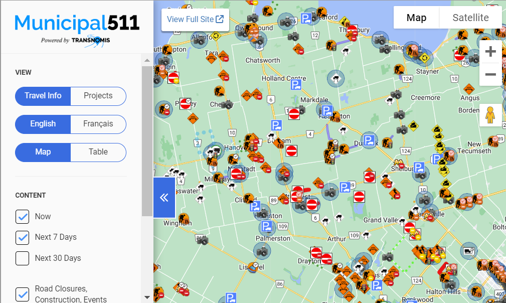
Municipal511 is a comprehensive mapping and road information management service designed for local governments and emergency services. It centralizes and streamlines the planning and communication of traffic disruptions, road closures, and construction updates across various road types including local, regional, and private paths. The platform features an intuitive dashboard and map view, facilitating the easy distribution of real-time road conditions and traffic impacts. Municipal511's integration capabilities extend to third-party apps like Waze and GIS, enhancing data accuracy and distribution efficiency. It supports diverse map views, customizable layers, and detailed visual representations, enabling users to accurately report and manage road issues. The system is accessible from any device with internet connectivity, simplifying road management without the need for specialized IT support. Municipal511 aims to improve operational efficiency, reduce administrative costs, and enhance
Screenshots

Categories
FAQ
The official website of Municipal511 is http://transnomis.com/
Municipal511 is a comprehensive mapping and road information management service designed for local governments and emergency services. It centralizes and streamlines the planning and communication of traffic disruptions, road closures, and construction updates across various road types including local, regional, and private paths. The platform features an intuitive dashboard and map view, facilitating the easy distribution of real-time road conditions and traffic impacts. Municipal511's integration capabilities extend to third-party apps like Waze and GIS, enhancing data accuracy and distribution efficiency. It supports diverse map views, customizable layers, and detailed visual representations, enabling users to accurately report and manage road issues. The system is accessible from any device with internet connectivity, simplifying road management without the need for specialized IT support. Municipal511 aims to improve operational efficiency, reduce administrative costs, and enhance
Municipal511 belongs to the GIS category.
No, Municipal511 does not offer a free trial.
Reviews(0)
Write a reviewMunicipal511 alternatives
Google Maps
Google Maps is a mapping software that provides users with an interactive map to view locations and directions. The software utilizes satellite imagery, street maps, and 360 panoramic views of streets to display geographic information for over 220 co...load more
EZO
EZO helps small businesses manage inventory and assets across multiple locations, with strong support for check-in/check-out workflows and real-time tracking. Reviewers highlight its ease of use and asset visibility, though some cite UI friction and ...load more
UpKeep
UpKeep is a maintenance management tool mainly used by small businesses in industries such as real estate, food and beverage, and healthcare that need to manage maintenance tasks across multiple sites. Its notable for its mobile-first design and prev...load more
MaintainX
MaintainX is a maintenance management tool used mainly by small businesses in facilities services, automotive, and food and beverage. It stands out for its mobile access and preventive maintenance scheduling, its intuitive interface, and real-time wo...load more
ArcGIS
Integrated collection of GIS software products; ArcGIS offers unique capabilities and flexible licensing for applying location-based analytics to your business practices. Gain greater insights using contextual tools to visualize and analyze your data...load more
Surfer
Surfer is the most complete platform for AI Search Optimization and visibility. It helps your brand show up where real decisions happenon Google, inside AI-generated answers, and across the web. With Surfer, you create content LLMs want to cite and t...load more
Asset Essentials
Asset Essentials is a cloud-based maintenance solution that generates operational insights from asset and work order management activities. The solution collects and consolidates facility asset data and repair histories, yielding increased asset visi...load more
Fulcrum
Fulcrum is a field-first SaaS platform transforming how organizations manage field data collection and inspections. Designed for the unique challenges of field teams, it automates workflows, captures real-time location data, and integrates seamlessly...load more
MapBusinessOnline
MapBusinessOnline is mapping software for business intelligence. Thousands of businesses choose MapBusinessOnline to generate insightful maps, manage territories, perform market analysis, optimize logistics, and more. MapBusinessOnline addresses all ...load more
BatchGeo
BatchGeo is a web-based tool that helps you quickly and easily create custom maps from your data. Simply copy and paste your spreadsheet or CSV file into BatchGeo, and it will automatically plot your data points onto a map. You can then customize you...load more