SkyDeck
Aerial insights software that allows users to capture, process and visualize data using drones and generate analytics and reports.
What is SkyDeck?
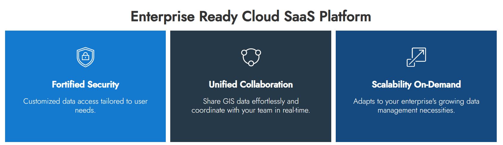
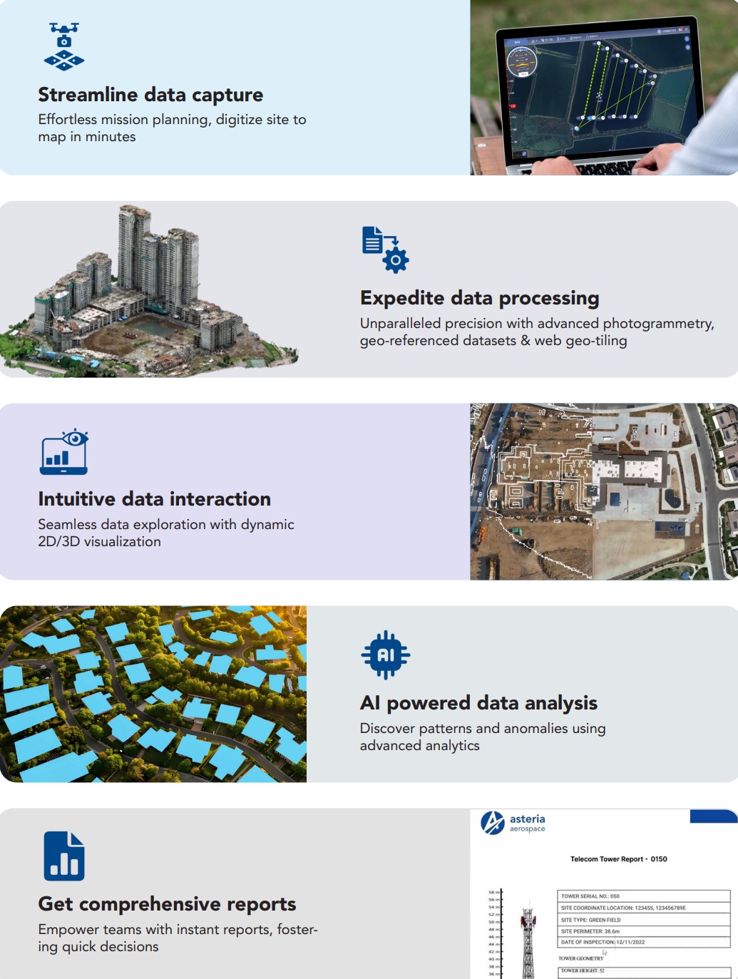
SkyDeck is a unified cloud-based SaaS platform for end-to-end drone fleet management, scheduling and executing drone flights, data processing, and visualization, AI-based analysis and reporting of aerial data captured using drones. SkyDeck ensures operational transparency, improves collaboration between stakeholders, and provides secure and centralized management for scaling drone programs across multiple applications. |Data Capture: mission planning, precision flights, on ground quality checks. Digitize site to map in minutes, with the accuracy of RTK/PPK geo-tagging. |Data Processing: high-resolution drone imagery, structured, geo-referenced datasets. Unparalleled precision with advanced photogrammetry and web geo-tiling. |Data Interaction: data exploration with dynamic 2D/3D visualization. Engage, analyze, and interact with data featuring overlay, tagging, and annotation. |Data Analytics: AI-powered insights, advanced analytics. |Instant cloud- based report from flight to finding
Screenshots
Categories
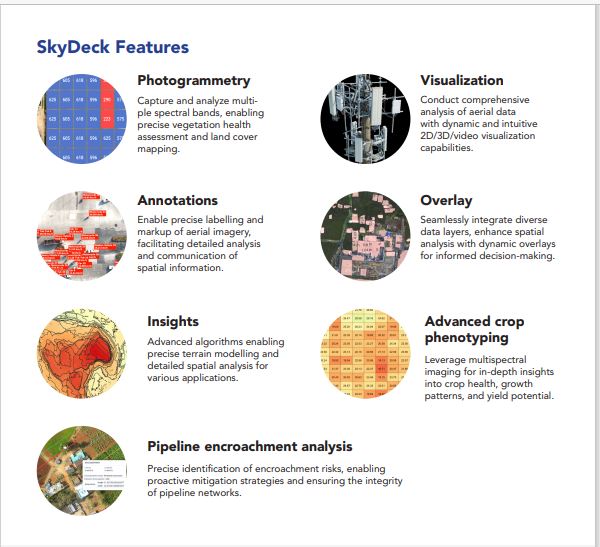
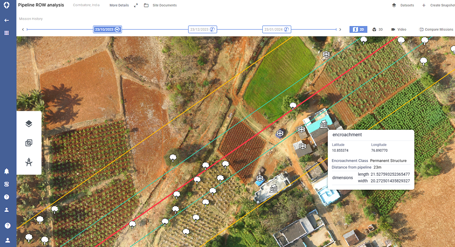
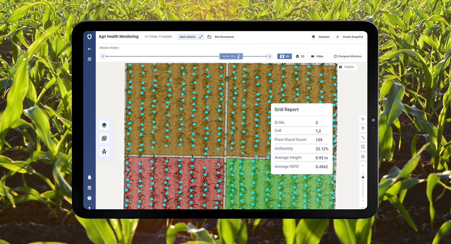
Features
FAQ
The official website of SkyDeck is http://asteria.co.in/
SkyDeck is a unified cloud-based SaaS platform for end-to-end drone fleet management, scheduling and executing drone flights, data processing, and visualization, AI-based analysis and reporting of aerial data captured using drones. SkyDeck ensures operational transparency, improves collaboration between stakeholders, and provides secure and centralized management for scaling drone programs across multiple applications. |Data Capture: mission planning, precision flights, on ground quality checks. Digitize site to map in minutes, with the accuracy of RTK/PPK geo-tagging. |Data Processing: high-resolution drone imagery, structured, geo-referenced datasets. Unparalleled precision with advanced photogrammetry and web geo-tiling. |Data Interaction: data exploration with dynamic 2D/3D visualization. Engage, analyze, and interact with data featuring overlay, tagging, and annotation. |Data Analytics: AI-powered insights, advanced analytics. |Instant cloud- based report from flight to finding
SkyDeck belongs to the GIS category.
SkyDeck offers features such as 3D Imaging, Color Codes/Icons, Data Import/Export, Data Mapping, Geocoding, Geographic Maps, Labeling, Map Sharing.
No, SkyDeck does not offer a free trial.
Reviews(0)
Write a reviewSkyDeck alternatives
Google Maps
Google Maps is a mapping software that provides users with an interactive map to view locations and directions. The software utilizes satellite imagery, street maps, and 360 panoramic views of streets to display geographic information for over 220 co...load more
EZO
EZO helps small businesses manage inventory and assets across multiple locations, with strong support for check-in/check-out workflows and real-time tracking. Reviewers highlight its ease of use and asset visibility, though some cite UI friction and ...load more
UpKeep
UpKeep is a maintenance management tool mainly used by small businesses in industries such as real estate, food and beverage, and healthcare that need to manage maintenance tasks across multiple sites. Its notable for its mobile-first design and prev...load more
MaintainX
MaintainX is a maintenance management tool used mainly by small businesses in facilities services, automotive, and food and beverage. It stands out for its mobile access and preventive maintenance scheduling, its intuitive interface, and real-time wo...load more
ArcGIS
Integrated collection of GIS software products; ArcGIS offers unique capabilities and flexible licensing for applying location-based analytics to your business practices. Gain greater insights using contextual tools to visualize and analyze your data...load more
Surfer
Surfer is the most complete platform for AI Search Optimization and visibility. It helps your brand show up where real decisions happenon Google, inside AI-generated answers, and across the web. With Surfer, you create content LLMs want to cite and t...load more
Asset Essentials
Asset Essentials is a cloud-based maintenance solution that generates operational insights from asset and work order management activities. The solution collects and consolidates facility asset data and repair histories, yielding increased asset visi...load more
Fulcrum
Fulcrum is a field-first SaaS platform transforming how organizations manage field data collection and inspections. Designed for the unique challenges of field teams, it automates workflows, captures real-time location data, and integrates seamlessly...load more
MapBusinessOnline
MapBusinessOnline is mapping software for business intelligence. Thousands of businesses choose MapBusinessOnline to generate insightful maps, manage territories, perform market analysis, optimize logistics, and more. MapBusinessOnline addresses all ...load more
BatchGeo
BatchGeo is a web-based tool that helps you quickly and easily create custom maps from your data. Simply copy and paste your spreadsheet or CSV file into BatchGeo, and it will automatically plot your data points onto a map. You can then customize you...load more